Champi Grazes Guam, Then Jumps to Category 5
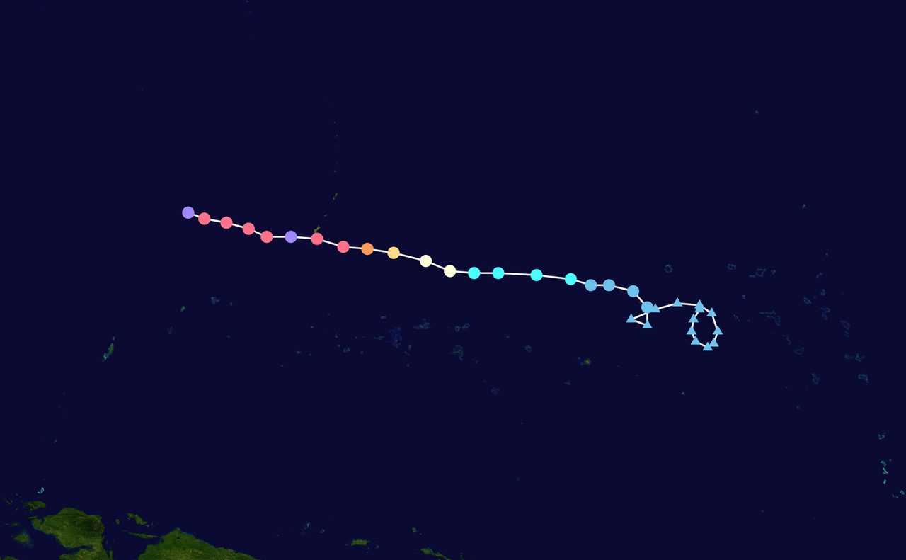
Photo: OreoStar-fait / Public domain · via Wikimedia Commons
Champi Grazes Guam, Then Jumps to Category 5
A ten-mile miss before dawn
The center of Super Typhoon Champi passed about 10 miles (16 kilometers) south of Merizo, on Guam's southern tip, at 4:26 a.m. local time on Sunday, Oct. 18. The eye stayed offshore. Only the northern eyewall brushed the island's far south. About three hours later, forecasters upgraded the still-departing storm to a super typhoon, with sustained winds of 150 mph (240 km/h).
Six hours later, a Category 5
The Joint Typhoon Warning Center initially analyzed Champi at 150 mph at 00:00 UTC on Oct. 18, then revised that same time stamp upward. Yale Climate Connections reported the revised intensity as 165 mph (265 km/h); The Watchers, citing the post-analysis, put it at 167 mph (269 km/h). Either figure clears the Category 5 threshold. Yale noted it was the ninth Category 5 storm observed anywhere in the world in 2026. The peak was brief: by 12:00 UTC the storm was down to 140 mph (225 km/h) as a second eyewall formed and dry air worked into the core.
"We were definitely spared the worst"
"We were definitely spared the worst," said Brandon Aydlett, the weather service's chief science and operations officer. He said a direct hit from a core that compact would have produced significant to catastrophic damage, especially to non-concrete structures. Guam International Airport recorded typhoon-force gusts of 80 mph, and storm-total rainfall across the island ran 8 to 14 inches. Aydlett said trees still showed plenty of green and preliminary reports found "no widespread significant damage," but the far south has little useful wind data; survey teams were due there on Monday to check wind damage and coastal flooding.
Half the island in the dark
The Guam Power Authority said only about 50 percent of customers had electricity at 7:50 a.m. Sunday, down from 75 percent shortly after the eye passed. By 9 a.m., 51 percent of distribution feeders were online, and there was no island-wide blackout. By 7 a.m. Monday, 70 percent of feeders were energized, but peak demand was just 90 megawatts, about 52 percent of normal — the lines were back before the load was.
Wells, water and turbidity
The Guam Waterworks Authority reported that by 6 p.m. Sunday, only 78 of 101 production wells were online, four of them running on generators. On Monday, 653 customers still had no water, and the utility urged conservation. The Ugum surface water treatment plant was secured and running on standby power because flooding in the Ugum River had pushed turbidity too high. Power, water and roads fail together here, and each link adds days to recovery.
Sixteen deliveries, three ER visits
Guam Memorial Hospital never lost power as the eye passed. It delivered 16 babies, and its emergency department treated three storm-related patients, including one minor injury; all were discharged. Late-term mothers had been asked to report to the hospital before the storm. As of Monday, officials had reported no deaths, aided by the two days the island spent at Condition of Readiness 1, its highest alert level.
Shelters, schools and a slow assessment
Six emergency shelters held 892 people on Saturday night, including 279 at Astumbo Elementary School. More than 300 people were still in school-based shelters on Monday, waiting for secondary sites to pass safety checks before they could be moved. Guam Department of Education schools were closed Monday and again Tuesday: buildings need inspection, and several are still shelters.
Federal aid and a closed airport
President Trump approved emergency declarations for Guam and the Commonwealth of the Northern Mariana Islands on Sunday, clearing FEMA to coordinate relief, with emergency protective measures funded at 75 percent federal cost. Gov. Lou Leon Guerrero had declared a local state of emergency on Oct. 16 and moved the island to COR 1 at 1 p.m. Saturday; the all-clear to COR 4 came at 6 p.m. Sunday. Airlines canceled flights into and out of A.B. Won Pat International, with cancellations extending into Monday. The U.S. Coast Guard held Port Heavy Weather Condition ZULU across Guam, Saipan, Tinian and Rota.
Warm water and a very small core
Champi climbed from tropical storm to Category 4 in about two days over sea-surface temperatures of 29 to 30 degrees Celsius, with weak vertical wind shear and strong upper-level outflow. Its wind field was unusually small and tight, which is why a 10-mile shift mattered so much. An eyewall replacement cycle then weakened the storm even as favorable conditions persisted.
Next stop: the Philippine Sea
The Philippine Atmospheric, Geophysical and Astronomical Services Administration said Monday morning that Champi was about 1,600 kilometers east of southeastern Luzon with maximum sustained winds of 175 km/h and gusts to 215 km/h, moving west-northwest at 20 km/h. It is expected to enter the Philippine area of responsibility on Tuesday morning or early afternoon and take the local name Rosal. PAGASA expects it to re-intensify from Monday evening, possibly back to super typhoon strength, before gradual weakening from Wednesday, Oct. 21. The track favors Taiwan, but a more southerly path clipping extreme northern Luzon has not been ruled out, with heavy rain over the Batanes-Babuyan area.
A season without a breather
Champi is the latest test in a brutal year for the Marianas. Super Typhoon Sinlaku struck in April and Super Typhoon Bavi in July. The Red Cross had already deployed about 85 additional personnel from Guam, Hawaii and the U.S. mainland for shelter and response work. The island got lucky with a 10-mile miss this time, but its poles, wells and shelters are running short on near misses.
Sources
- Yale Climate Connections
- The Watchers
- Pacific Daily News
- Post Guam
- RNZ