Super Typhoon Champi's 56-Kilometer Eye: Strongest Storm of 2026
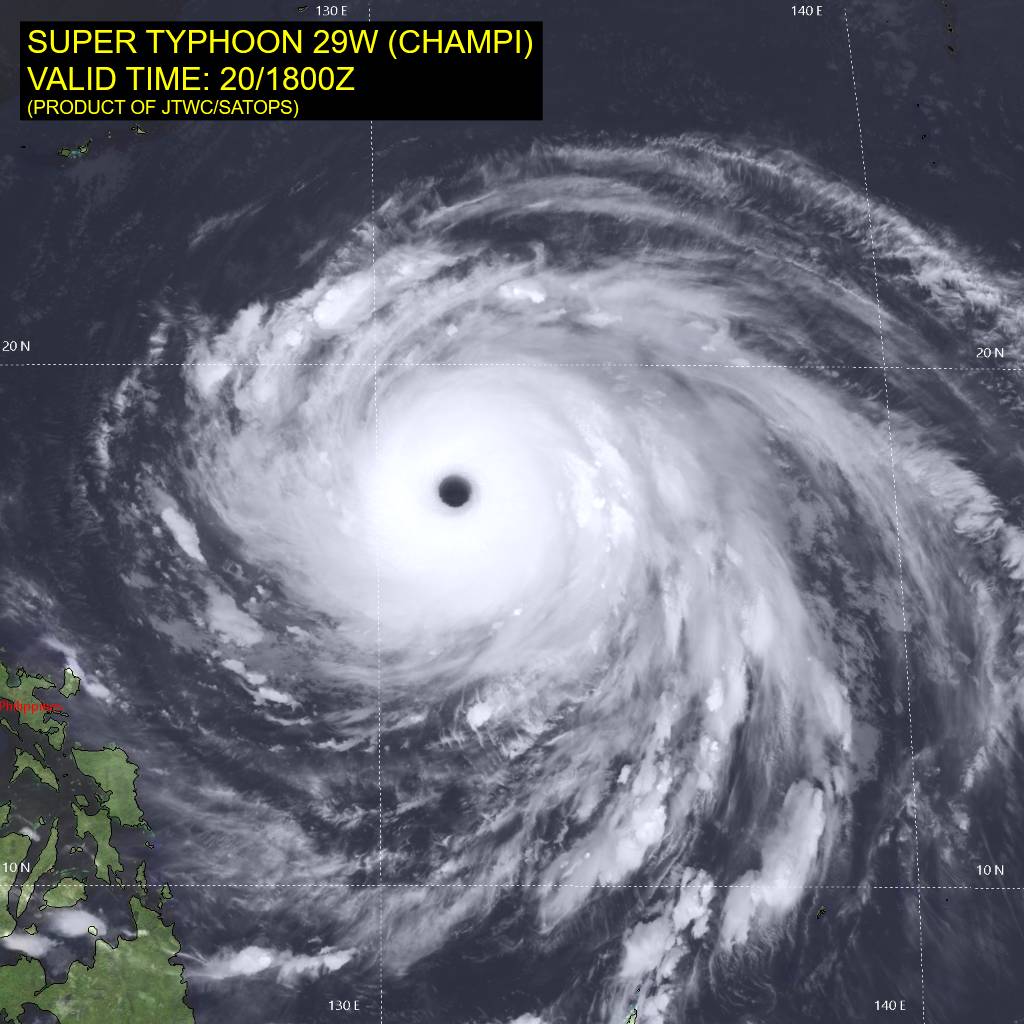
Photo: Joint Typhoon Warning Center / Public domain · via Wikimedia Commons
Typhoon Champi's 56-Kilometre Eye Makes It the Strongest Storm of 2026
Born October 11, designated the season's thirtieth storm
Typhoon Champi, called Rosal in the Philippines, is the thirtieth named storm of the 2026 Pacific typhoon season. It grew out of a tropical depression near Micronesia on October 11 and tracked generally northwest, being designated 29W by the Joint Typhoon Warning Center on October 14 (Watchers.news).
A rare pinhole eye caught on satellite
The Cooperative Institute for Meteorological Satellite Studies at the University of Wisconsin-Madison documented that, after sunrise on October 17, Himawari-9 visible imagery revealed low-altitude mesovortices swirling inside Champi's pinhole eye, while a packet of gravity waves propagated northwestward and disturbed cloud tops on the storm's southern flank (CIMSS Satellite Blog; Futura Sciences). Microwave imagery on October 20 showed Champi had cleared out a very large, warm (+22°C) and clean eye bounded by a single, very intense eyewall (Super Typhoon Champi (29W/Rosal) – Tropical Cyclone Advisory #14).
Eye measured roughly 56 kilometres across
On October 21, satellite imagery showed a well-defined eye approximately 56 kilometres (35 miles) across inside a symmetrical central dense overcast. JTWC estimated significant wave heights near the cyclone at 19.8 metres (65 feet) (Watchers.news).
NWS calls it a Category 5 equivalent
On October 20 the US National Weather Service reported maximum sustained winds of 180 mph (about 290 km/h), making Champi Category 5 equivalent. That ties Hurricane Polo for the year's second-highest peak wind speed, behind Super Typhoon Sinlaku at 185 mph (Rollingout; Yahoo News). NASA's MODIS program put the peak at 296 km/h (185 mph) on October 20, making Champi the strongest tropical cyclone of 2026 so far by wind speed (Watchers.news).
Warm water and weak shear did the work
India Today reported that sea surface temperatures in Champi's region were around 30°C, slightly above normal for the season, and that relatively weak winds at different heights in the atmosphere allowed the storm to keep its structure and strengthen. Warm seas supply heat and moisture, while weak shear lets the eyewall develop without being disrupted (India Today).
Guam got a ten-mile miss
Guam's Joint Information Center reported that Champi made its closest point of approach at about 4:26 a.m. local time on October 18, passing about 10 miles south of Merizo, with southern Guam bearing the brunt of damaging winds and heavy rain (Guam Homeland Security JIC Release No. 12). The Pacific Daily News reported the centre passed roughly 13 to 15 miles from Malesso' and that the island escaped a direct hit at 150 mph Category 4 strength (Pacific Daily News).
Half the island lost power
Shortly after the closest approach, about 75 per cent of the island still had electricity at 5:30 a.m. on October 18; by 7:50 a.m. that morning roughly half the island was dark as feeders in central and northern Guam began tripping (Guam Homeland Security JIC Release No. 13; Pacific Daily News). By 7 a.m. on October 19, 653 water customers had no service, about 30 per cent of feeders were offline and 70 per cent energised, and peak demand was 90 megawatts — roughly 52 per cent of normal (Pacific Daily News).
Signal No. 2 over Batanes and Babuyan
PAGASA's 11 a.m. bulletin on October 22 placed Rosal about 400 kilometres east of Basco in Batanes, with maximum sustained winds of 185 km/h and gusts of 230 km/h, while Signal No. 2 remained hoisted over Batanes and the northeastern part of the Babuyan Islands (Philippine Daily Inquirer). A day earlier, at 11 a.m. on October 21, the centre was 845 kilometres east of northern Luzon, carrying 215 km/h sustained winds and gusts of 265 km/h (Philippine Daily Inquirer).
Taiwan declares land and sea warnings
Taiwan's Central Weather Administration issued a land warning on October 22 covering Yilan, Hualien, Taitung and Pingtung counties, with the storm roughly 250 kilometres southeast of Yilan, gusts above 227 km/h near the centre, a typhoon radius expanded to about 320 kilometres, mobile alerts warning of waves above 6 metres, and nearly a metre of rain expected in northern mountain areas (Taipei Times; The Straits Times). Taiwan's transport ministry said 125 flights were cancelled on Thursday, mostly domestic (The Straits Times).
China expects a Saturday landfall
China's National Meteorological Centre said Champi was expected to make landfall on the eastern coast of Taiwan around Saturday and then again in Fujian province as a severe tropical storm, issuing a blue typhoon warning — the lowest of China's four-tier system — while eastern Zhejiang drew up evacuation plans for vulnerable communities (The Independent). In Japan, Japan Airlines, ANA and Skymark cancelled more than 100 mostly domestic flights between Thursday and Sunday, disrupting travel for over 11,000 passengers (Japan Today).
Turning north toward Japan and the Yellow Sea
Forecaster Chang Cheng-chuan said Champi would be at its closest to Taiwan late on Friday off the northeastern coast before heading north toward the seas off Shanghai, with warnings expected to be lifted on Saturday afternoon as the storm moved toward Kyushu (The Independent). Philippine forecasters expect the cyclone to exit the Philippine Area of Responsibility by Friday evening or early Saturday and to weaken to a severe tropical storm by Saturday (GMA News).
Sources
- Watchers.news: Super Typhoon Champi becomes the strongest tropical cyclone of 2026, Signal No. 2 remains over Batanes, Philippines
- Yale Climate Connections: Super Typhoon Champi intensifies to a Cat 5 after battering Guam
- The Independent: Taiwan cancels over 100 flights as Super Typhoon Champi churns towards island with 140mph winds
- The Straits Times: Taiwan issues land warning ahead of arrival of powerful Typhoon Champi
- Philippine Daily Inquirer: Signal No. 2 still up in Batanes, parts of Babuyan Islands